Now that we're half way through November, something that I'm getting asked often at the moment, is when will it get really cold and when will it snow? Obviously if I could answer either of those questions with any degree of certainty, I would be a very wealthy man! Medium and long range forecasting (anything further out than a few days) is not a simple business!
One of the issues is the fact that the general public are used to deterministic forecasts. These are the types of forecasts we hear everyday on the radio, the TV or here on FifeWeather. They are deterministic, as they aim to provide (determined) specifics about weather conditions at certain times of the day, normally for the next 24 to 72 hours.
When I get asked these questions about severe cold and snow, most folk have the expectation that I will be able to provide a "deterministic" answer to the question, and it's just not possible. Instead, when we talk about medium or longer term forecasting, we're really talking about "probabilistic forecasting", that is, the likelyhood or chances of potential weather outcomes, rather than a specific set of predictions.
Taking that approach, we can get an idea of what the most likely forecast outcome is in the longer term, in a general sense. So returning to the original questions posed above, how are things looking into late November/early December?
At this stage, the models are indicating a trend towards colder, dryer conditions, coupled with high pressure. A good example of this is by looking at the GFS forecast ensembles - a series of forecast model outcomes run with slightly varying initial parameters. As each forecast run (or "member" - represented by a coloured line in the chart below) progresses, it starts to deviate from other ensemble members. When several ensemble members "clump together", a higher degree of confidence can be placed on that outcome.
Here's the current GFS ensemble run for the average temperatures over the next couple of weeks, for Fife (click graph to enlarge):
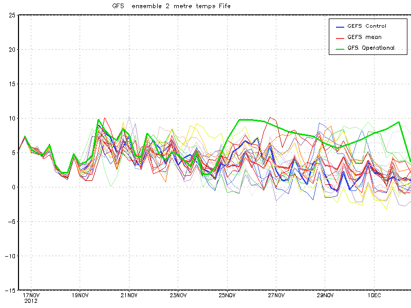
As you can see from this graph above, most of the graphed lines (each member of the ensemble) are grouping towards a downward trend in average temperature as November progresses.
Here are the ensemble runs for air pressure over Fife (click graph to enlarge):

The trend here is for most of the member runs to show an increase in air pressure over Fife (and indeed the UK in general).
So what can we glean from this information? Essentially it is looking like we're going to get colder temperatures under high pressure as November draws to a close. What this means in terms of actual conditions on the ground (such as frosts/freezing fog or the infamous "s" word) will depend entirely on how these potential outcomes manifest themselves. For example, even small shifts in the position of a high pressure system in the vicinity of the UK, can greatly affect the specifics of the outcome.
But it does look like things are set to cool down and dry up (precipitation is also trending downwards, as would be expected under the influence of high pressure) as the final month of the year looms.
(GFS Ensemble graphs, courtesy of Netweather.tv, reproduced with permission)